skip to main | skip to sidebar

International Education Statistics

Updated "Guide to creating maps with Stata"

The guide to creating maps with Stata has been updated with new links to third-party software.

Map created with spmap in Stata: length of country names
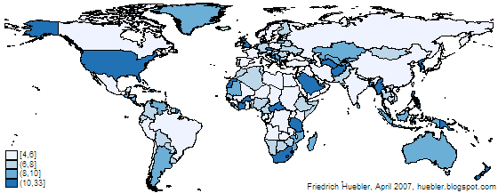
Example map created with spmap in Stata

Related articles
  • Guide to creating maps with Stata
  • Guide to integrating Stata and external text editors
  • Guide to creating PNG images with Stata
  • Guide to reading Statalist with Gmail

Friedrich Huebler, 30 June 2009, Creative Commons License
Permanent URL: http://huebler.blogspot.com/2009/06/stata-maps.html
Labels: map, software, Stata
Newer Posts Older Posts Home
Subscribe to: Posts (Atom)

Blog Archive

  • ►  2012 (1)
    • ►  April (1)
  • ►  2011 (12)
    • ►  October (1)
    • ►  September (2)
    • ►  August (1)
    • ►  July (1)
    • ►  June (1)
    • ►  May (1)
    • ►  April (1)
    • ►  March (2)
    • ►  February (1)
    • ►  January (1)
  • ►  2010 (13)
    • ►  December (1)
    • ►  November (1)
    • ►  October (1)
    • ►  September (2)
    • ►  August (1)
    • ►  July (1)
    • ►  June (1)
    • ►  May (1)
    • ►  April (1)
    • ►  March (1)
    • ►  February (1)
    • ►  January (1)
  • ▼  2009 (15)
    • ►  December (1)
    • ►  November (1)
    • ►  October (1)
    • ►  September (1)
    • ►  August (1)
    • ►  July (1)
    • ▼  June (1)
      • Updated "Guide to creating maps with Stata"
    • ►  May (1)
    • ►  April (1)
    • ►  March (2)
    • ►  February (2)
    • ►  January (2)
  • ►  2008 (1)
    • ►  December (1)
Powered by Blogger.
 
financial services, manufacturing industry, Home Remodeling, 911 communications, Used Cars, Mountain Biking, wealth magazine europe, the media network, quotes journalism media, green technology, news today, education in spanish, Medical Health Care, Dive West,